In the dynamic world of public safety, effective after-action reports (AARs) and robust training are paramount to continuous improvement. Imagine a football coach meticulously drawing up a play formation, outlining every player’s position and intended movement. During the game and after, coaches and even players on the sidelines review earlier action on a tablet to see where the outcome of the play aligned with expectations, and where something unexpected happened. This is precisely the power that CommandCentral Aware brings to public safety agencies.
Just as a coach analyzes game footage to refine strategies and train players, public safety agencies can leverage CommandCentral Aware’s Historical Map to visualize, analyze, and learn from past incidents. By combining the ability to “draw up plays” with the Markups tool and then “replay” them using the Historical Map, agencies can revolutionize their AARs and post-incident training.
Drawing the “Play”: Pre-Incident Planning with Markups
The Markups tool allows agencies to annotate maps with important information, effectively “drawing up the play” before an incident even occurs. This pre-planning can be invaluable for a variety of scenarios including:
- Strategic Deployment for Large Events: For planned events like parades, festivals, or protests, agencies can use markups to designate officer positions, establish perimeters, indicate public access points, and mark locations for medical stations or command posts. These “playbooks” can be saved and shared, ensuring everyone involved has a clear understanding of the operational plan.

Example shown: Pre-staged unit locations marked on the map ahead of the planned Fourth of July event in Columbia County, Georgia
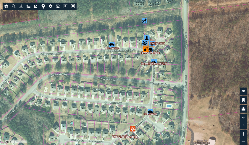
- Targeted Operations (e.g., Search Warrants): Before executing a search warrant or other targeted operation, detailed intelligence gathering and planning are crucial. The Markups tool can be used to diagram the target location, noting potential entry and exit points, hazards, or even suspect strongholds. This visual blueprint can guide officers during the operation and serve as a reference point for post-incident analysis.

Example shown: Lee County Sheriff’s Office (NC) Preplan for Search Warrant
Reviewing the “Play”: Historical Map for Post-Incident Analysis
CommandCentral Aware’s Historical Map allows agencies to “replay” incidents, providing a dynamic visual record of events as they unfolded. When combined with the pre-planned markups, this becomes an incredibly powerful tool for AARs and training:
- Visualizing Officer Movement vs. Plan: Agencies can overlay the actual GPS tracks of officers and vehicles from the Historical Map onto the pre-planned markups. This allows for a direct comparison of where officers were planned to be versus where they actually were. This visual discrepancy (or adherence) can spark discussions during debriefs, identifying areas for improvement in communication, deployment strategies, or even individual officer positioning.
- Tracking Suspect Movement and Evidence Recovery: The Historical Map can show the path of suspects, and if tactical dispatchers or Real-Time Crime Center operators are actively marking events, the locations where evidence was discarded or recovered can be pinpointed. For example, if suspects discarded firearms during a foot chase, the Historical Map would show the path of officers alongside the exact location of any discarded evidence marked on the map. This provides irrefutable evidence for court and a clear visual for training on evidence recovery during pursuits.
- Analyzing Response Times and Convergence: The Historical Map can demonstrate how quickly officers converged on an incident and from what directions. Agencies can see key timestamps on the map to show when units were dispatched, when they arrived on scene, and when an incident was brought under control. This is invaluable for analyzing response protocols and identifying potential bottlenecks or areas where faster deployment could have improved outcomes. The Historical Map clearly shows their routes and arrival times.
- Reviewing Jurisdictional Boundaries: Agencies often operate across multiple jurisdictions. The Historical Map can be used to show the path of officers and marked evidence in relation to these boundaries. This is particularly useful in incidents that may span city limits, county lines, or even university property, as shown in the example of firearm recovery from Greenville, NC Police Department below.
- Substantiating Actions for Court and Public Review: A visual, time-stamped replay of an incident, complete with officer GPS data and marked key events, provides clear and straightforward evidence. This objective record helps to counter claims of misconduct and clearly illustrates the actions taken by law enforcement.
Enhancing Training with “Real-World Plays”
Beyond AARs, the Historical Map with markups transforms post-incident training:
- Case Studies with Visual Impact: Instead of abstract scenarios, instructors can present real-world incidents using the Historical Map. This allows trainees to visualize the actual environment, officer movements and decision points. Markups can highlight key areas of interest, such as where an officer encountered resistance or where an important piece of information was relayed.
- Developing Tactical Acumen: By reviewing the “plays” of past incidents, officers can learn from both successes and challenges. They can analyze why certain tactics were effective or why others failed, fostering better decision-making skills in high-stress situations. For example, understanding how a foot chase unfolded and how officers coordinated their efforts can provide valuable lessons for future pursuits.
- Improving Evidence Collection and Scene Management: The ability to backtrack officer paths and mark evidence locations visually reinforces best practices for evidence collection and scene management after an incident is resolved.
CommandCentral Aware offers public safety agencies a powerful analytical platform for training and AARs. By moving beyond static reports to dynamic, visual representations of incidents, agencies can create more impactful AARs, conduct more effective training and ultimately enhance their operational readiness and community safety.
Learn more about CommandCentral Aware here or log in to CommandCentral Aware here.


